The first time I came to campus when
I was a Junior in High School, my cousins gave me a pretty insider-esque tour
of the area. Even though the highlight of the trip for me at the time was the
final stop at Ben & Jerry’s (RIP),
I couldn’t help but note Dinkytown as we circled Washington by the new stadium
and headed west on 4th. As we passed McDonald’s and drove though the
campus social center on the way out, I initially thought that the Dinky Ditch
was actually a creek of some sort, providing a long segment of open space and
trails for the students and community. I was quite saddened to see it was only
an old, essentially abandoned rail ditch (Which I learned later is truly
historic in a way… it was one of the rail lines that once crossed the Stone
Arch Bridge).
Now after attending the U for a
couple years, I’ve kept my eye and done my research about this prominent ditch
that splits campus from Dinkytown, and cant help but question its present
condition as a passive rail yard. With the ditch in the location that it is,
there should be no reason why it can’t be changed to something more intriguing
for the surrounding population, turning it into something like this.
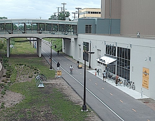
In fact, the University and the City
have tried to facilitate that slow transformation by changing the old Northern
Pacific #9 Bridge into a non-motorized
trailway. Currently, the trail awkwardly ends behind the Education Sciences
Building (at a delightful Dunn Bros Café
which most people don’t seem to ever notice). However, the University has also
persisted through many land ownership arguments to finally connect the bridge
and create the U of M bike trail, which
should be open by year’s end. Even though the City had to do a split-trail agreement with the U that requires the trail to be built on part of the existing road, the path is currently only used for service vehicles, so the present cars won't make a significant difference. This is great news for commuting professors or
off-campus students to the West, as they now don’t have to maneuver through this as much.
 |
| Wouldn't a bike trail look great on those rail tracks? |
However, the ditch has some other
interesting proposals, including the much-discussed Granary Road Corridor, a semi-truck-ready road that could carry
trucks from I-35W to the industry near MN-280 without driving down University/4th
Street. This obviously wouldn’t be just for industrial traffic, as everyday
commuting drivers could also use it. This also means that it could also
possibly bring a substantial amount of commuters off of University/4th
as well. In a long term scope, this also means commercial or residential
development could move into the ditch (Which I will touch on a later date).
This brings up a discussion, though
– as the U of M bike trail is implemented, it will, at least initially,
resemble the Midtown Greenway in the sense of its segregated ditch location.
This brings up the question: Would a road carrying all types of traffic be
destroying the purpose of the segregated trail? Wasn’t the purpose of the
Midtown Greenway to separate the two types of traffic, allowing a lowering of
stress for both auto/bike users and pedestrians? Or, with college students
being as daring as they are anyways, would it not matter that an industrial
road is juxtaposing the trail? I mean, it does work in places, including the
stretch of the Diagonal Trail along Stinson
Boulevard north of Como.
Regardless of what happens to the
ditch in the long run, the implementation of the U of M Trail is a great
catalyst for the area north of campus which currently lacks a segregated bike
trail. It could also help ease the minds of college hipsters like this.
I love your link to the Portlandia bike sketch at the end. Classic!
ReplyDelete